THE ROLE OF THE LANDSCAPE IN THE PARIS-SACLAY PROJECT
MDP Michel Desvigne Paysagiste
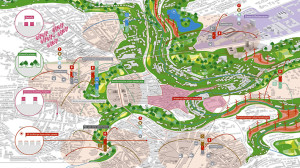
The challenge of the Paris-Saclay project was that of establishing a coherence and relationship among a multitude of places and actors within a well-defined physical scenario. The success of the project and its completion over a period of decades necessitate a process of continuous comparison among the numerous and different actors involved. The project embraces three dimensional scales, which also represent the three fil rouge of the project: Paris-Saclay at the territorial scale (an area of 7,700 hectares), Paris-Saclay at the scale of an urban campus (an area of 650 hectares), Paris-Saclay at the scale of the quarter. The territory of the Plateau is characterised by a number of potential continuities, unified and identifiable systems that can inspire a clear and recognisable backbone for the project: the series of forested hills and valleys that connect the Plateau with the plains around them. The operation to be pursued is that of completing and amplifying existing spatial conditions, integrating them with the system of mobility infrastructures, public transport and slow mobility.